Reports from the
Ancient Oaks
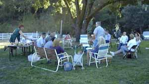
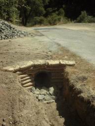
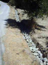
communityNews: Road Culvert Completed! (June 2003)
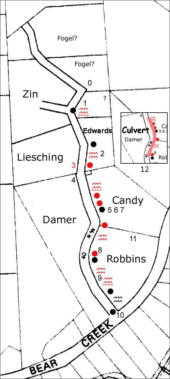
Original Ancient Oaks Community Road Drainage Proposal
(2000)
Legend
Reasoning for the drainage plan
We have considered moving the water across the road at the bottom of the Edwards (at 2-3 on the map) and down into the streambed on the west side of the road. After extensive examination, this option presented a couple of problems:
1. culverting under the road and extensive work to get it down behind Lieschings barn (they dont want it between their barn and house) will be a large project.
2. culvert capacity on the Damer property (three) and ditches would have to be upgraded to carry the extra water
3. there is an extensive water saturation problem in the bottom of the valley on the Damer/Liesching properties that will be exacerbated
3. the road still accumulates a large water flow on its east side along its full length, necessitating proper drainage system anyway.We concluded that the proper drainage for the entire length of the road was the best long term and permanent solution for the drainage off all properties. This plan is described next.
Top to Bottom Notes
0. Swale constructed by Bob takes safely water off road to canyon behind
1. Pipe which seems to drain from Zin's driveway is one initial source of water. Ditch becoming very deep here and could use gravel or paving or other form of treatment before road edge is endangered
2. Watercourse now going through field by McEdwards/Redig's, new ditch could be constructed down to end of property, new culvert to maintain access to field
3. Area in front of Liesching's barn to be built up and birm constructed to keep water buildup from this area. Road tilts toward this area carrying a significant amount of water, birm could redirect this toward the drainage system on east side. There may be rodent holes carrying water into this area also that ditch on East side might alleviate.
4. Small birm on upper part of Damer property now keeps small amount of water from going down hillside to Damer upper meadow (which becomes a swamp), deflecting water toward the single drainage system on East side of road. From this point road is always sloped to the East.
5. Existing small diameter pipe under Donna's (Gordon's) driveways not carrying any water (inadequate diameter for full flow). This pipe would be replaced by single pipe or several sections of new conduit.
6. SLV water service across road to Candy's must be scoped out and pipe kept away from it.
7. Live power lines underground soon to be disconnected redirected overhead, now poses hazard to drainage through area in front of Donna's by pole.
8. Water turning corner in front of Robbins barn must be carefully ditched or culverted. There may need to be both a culvert to carry the roadside water (12) and a swale to catch water coming from further afield. Upper access to Robbin's has existing pipe (partly squashed) to be replaced by larger diameter pipe.
9. Hillside by Robbins needs to be knocked back a bit for ditching and then optional pavement/curb style drainage could carry water down to Robbin's existing pipe under their lower driveway. SLV water mains are in this area and would have to be planned for. We believe an SLV main is leaking here and they should look at this prior to our work.
10. Pipe underneath access road for Ancient Oaks is rusting and needs replacing by larger diameter pipe (sometimes it cannot carry the capacity, see picture below). Do the roads department give any support here as this is on the easement to Bear Creek Road?
11. Gopher hole or spring on Frank's property we hope to stop the flow to by the drainage project.
12. Frank Robbin's concept for a single culvert pipe rounding the corner.Descriptive Text for Proposed Work
The following is a play by play description of what the proposed work might entail. Starting with the "grand canyon" ditch from the Zins to the Edwards to be filled and/or paved to culvert under Edwards driveway. On the southern end to be ditched down to the end of the Edwards property where a culvert would be installed to permit driving access to their field. From that point a paved ditch next to the roadway (and pavement abutting and sealed to the road pavement) to go along Candy's property to first new culvert. Single or series of new culverts (see 12) to take water under three entrances to Candy's around the corner next to Robbins'. Ditch or single culvert to go under Robbins' upper entrance. From this culvert joining into ditch or paved curbed ditch to go along roadside by Robbins until it enters Robbins' existing lower culvert. Thereon water will flow in existing ditch down behind mailboxes and into Bear Creek road drainage.
Specs On Work
1. Most work would occur on the community parcel, 4-5 feet on either side of the road, but some would have to involve the edges of community parcels.
2. One foot diameter pipe (or more) in places where drive-over access is needed.
3. Paved ditches with curbs in places, ditches well away from road in other places
4. Professional grade work would be sought to last us for years.
5. Some patching could be done while this larger job is taken on.
6. Sealing of the road by pouring tar material in the now-forming cracks will also go a long way to extending the life of the road.
7. The road should be swept and kept clean of stones that could cause damage.
8. We might consider speed bumps at locations to slow cars and provide additional water coursing.Community Contributions
1. Each property owner would contribute equally to the project, and a simple majority would have to approve the bid/contractor to be used.
2. Contributions would be required up front to be held in trust by an assigned community member.
3. We should talk about forming a road association, possibly seeking ongoing contributions for maintenance in the future.Images of the Road
Sources at top, by Zins, and "grande canyon" ditch
By Redigs/McEdwards
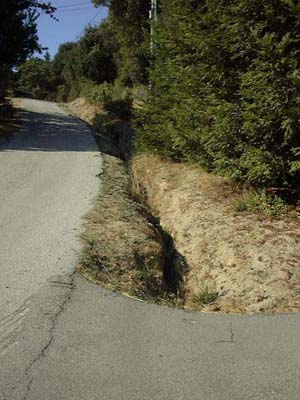
Coming down by Redig/McEdwards meadow, Lieschings on other side
Curve by Candy/Robbins, needs a lot of culverting work (12 above)
Storm Flows
Note that the flows shown here will easily quadruple with the additional water flow
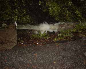
Water flow by Damer/Robbins off to east side where drains need to be constructed
Robbins culvert on lower drive showing adequate capacity
Proper drainage dug by Damer in winter 99/2000
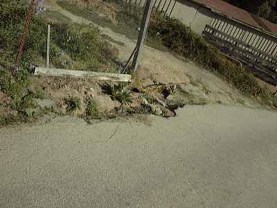
At Bear Creek Road, showing maxed out pipe
![]()
Click here to contact Bruce or send comments on this website.
[ home | news | projects | photos | art | pen | voice | vid | contact | search ]
(cc) 1996- Bruce Damer... want to use something from this site? See rights granted under my Creative Commons license and contact me.